Hunga Tonga: now there's a name you don't hear every day!
On 14 January 2022, the underwater volcano Hunga Tonga - Hunga Ha'apai violently exploded, sending clouds of ash 20 km (that's 12 miles!) into the stratosphere in what has been described as the largest volcanic eruption on Earth in 30 years. The ash plume, clearly visible from space, temporarily blotted out the sun in Nuku'alofa, Tonga's capitol city on the main island of Tongatapu, and sent tsunami waves tumbling across the Pacific Ocean.

Dramatic flashes of volcanic lightning were captured in photos:

Shockwaves were heard distinctly in New Zealand, more than 2,000 km (1,200 mi) away, where residents across the country reported hearing a loud boom around 7 pm Saturday. There were even reports of the noise being detected as far away as Alaska, more than 9,000 km (5,800 mi) distant! The tsunami waves generated by the event traveled as far and wide as Australia, Fiji, Japan, and even the North American coast where, among other effects, a parking lot near the Upper Harbor in Santa Cruz was flooded.
The volcano, located about 62 km (39 mi) north of Tongatapu, has been periodically erupting since December of last year. But what's especially fascinating is that this is just the latest iteration of a Pacific island saga that has literally been running for thousands of years. A volcanic eruption that began in late 2014 created a new, isolated third island between the twin islands of Hunga Tonga and adjacent Hunga Ha'apai. Both islands lie on the rim of the caldera of the "highly unstable" volcano that just erupted, which rises some 1800 meters off the surrounding sea floor. In addition to wiping out the local vegetation, the 2014-2015 event approximately doubled the size of Hunga Ha'apai, and over time the new crater-shaped island in the middle connected up with it. Eventually so much material had been thrust up above sea level that a land bridge had joined them all together to create one giant island, the now-defunct island of Hunga Tonga - Hunga Ha'apai:

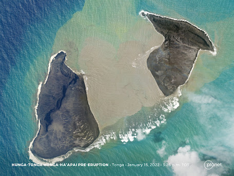
Note the dendritic erosion patterns, known as "rilling", on the surface of the volcanic deposits:

But it seems that thanks to the latest massive eruption, Hunga Tonga and Hunga Ha'apai are now once again separate islands! (It's unclear why this photo is labeled "pre-eruption", as by 3:25 pm on January 15 the event was already well underway).
Fortunately, the short-lived island was virtually uninhabitable, so no locals were injured or lost any valuable real estate. However, several species of flowers and birds might indeed be genuinely upset about the loss. And, tragically, two people have drowned in Peru as the result of 2 m (6.5 ft) tsunami swells.
So why are these undersea eruptions so violent?
Volcanic activity in the Earth's crust is closely associated with subduction zones, boundary regions where heavier tectonic plates are subsumed (or "subducted") beneath lighter plates, a process which typically occurs at the convergent area between heavy, dense oceanic crust, known as the oceanic lithosphere, and lighter continental crust. This is why, for example, Mt. St. Helens is located near the boundary between the largely sub-aquatic Juan de Fuca and the continental North American plates. But because subduction zones are places where the Earth's crust literally sinks into the mantle underneath, the majority of plate boundaries are entirely submerged, resulting in deep oceanic trenches along which volcanic arcs often form. It's no coincidence, then, that the Tonga archipelago was formed in close proximity to the Tonga Trench, second in depth only to the famous Mariana trench, over 10,000 m (35,000 ft) deep. Here, the Pacific plate is mutually subducted with the neighboring Indo-Australian plate. Volcanic arcs are usually found around 200 km from such an oceanic trench.
Whereas in a more typical, "slow-burn" eruption undersea jets of molten magma are steadily released into the water, giving it time to cool down thanks to an enveloping layer of steam, sometimes pockets of hot volcanic gas form pressurized bubbles underneath the rocky substrata. When these bubbles burst, the surrounding seawater reacts violently with the magma, something "akin to weapons-grade chemical explosions" according to Shane Cronin, professor of volcanology at the University of Auckland. In what researchers call a "fuel-coolant interaction", the magma is torn apart in a chain reaction-like sequence as the hotter inner material is continuously exposed to the cold sea water. Studies indicate that the last such large-scale explosion at Hunga occurred around 1100 CE, rendering the timing of the present event hardly surprising.
In fact the entire region is dotted with underwater volcanoes. The nearby undersea volcano Fonuafo‘ou, formerly known as Falcon Island, is another hotbed of geological activity, with known eruptions having occurred there in 1877, 1885-86, 1894, 1921, 1927, 1928, 1933 and 1936, often creating temporary land masses that subsequently collapsed and vanished beneath the waves. According to Volcano Live, Fonuafo‘ou is now some 17 m (56 ft) underwater.
It's incredible to think that we owe the existence of all land masses
on our planet to this ceaseless pyroclastic activity. We are the products of a vast geochemical dynamo fueled by the energy of matter itself. And it's a stark reminder that what we take to be solid ground beneath our feet is, to borrow a famous quote from Star Wars, "not entirely stable". It is instead constantly renewing and rearranging itself, a process as old as time itself, and one that will undoubtedly continue long after we're gone.
No comments:
Post a Comment